


Improving Mobility for All
Improving Mobility for All
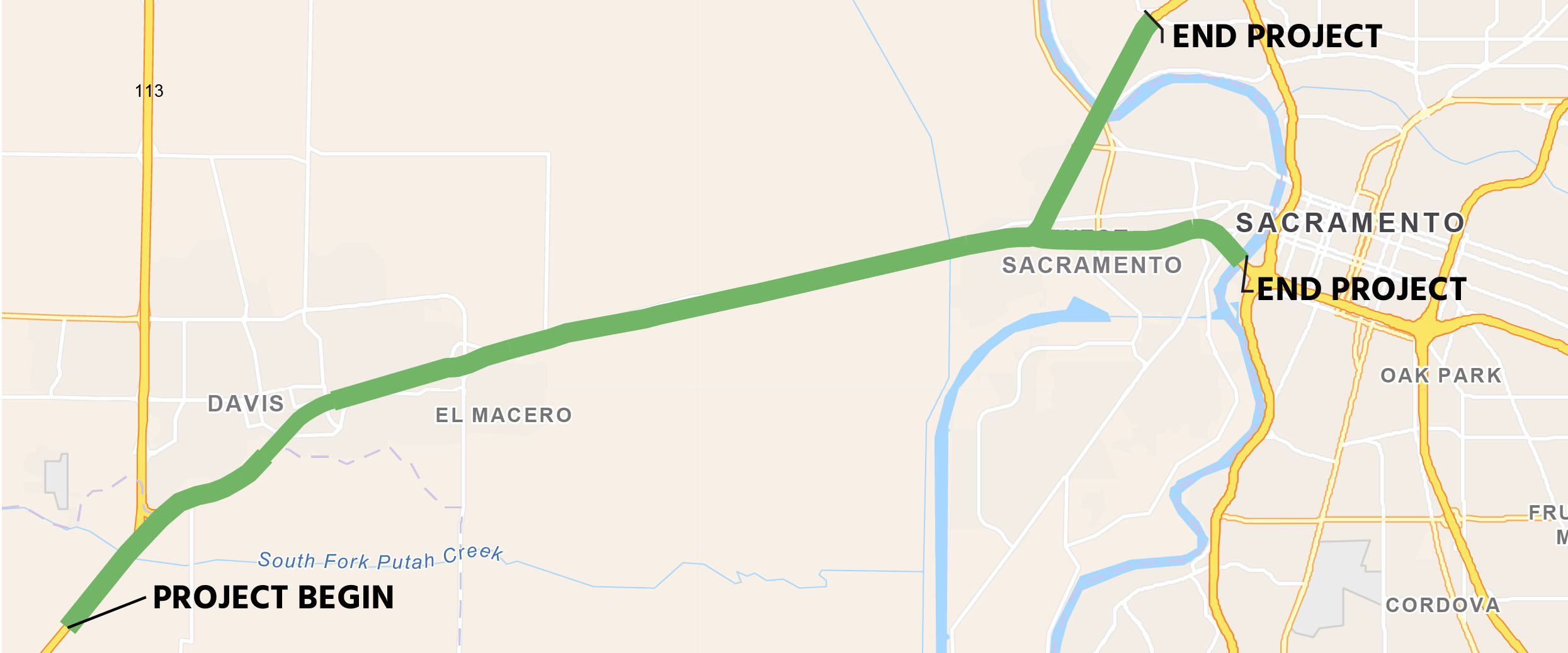
Yolo Transportation District (YoloTD) and the California Department of Transportation (Caltrans), in collaboration with other stakeholders, have joined forces for a freeway expansion initiative aimed at enhancing traffic flow within the I-80 corridor on the west side of the Sacramento-Yolo metropolitan area. This project has multiple components, including:
- Approximately 17 miles of tolled managed lanes
- New lane construction
- Intelligent transportation system (ITS) enhancements (e.g. fiber optics, detection, changeable message signs, to enhance mobility conditions and incident management strategies)
- Improvements to cycling and pedestrian facilities
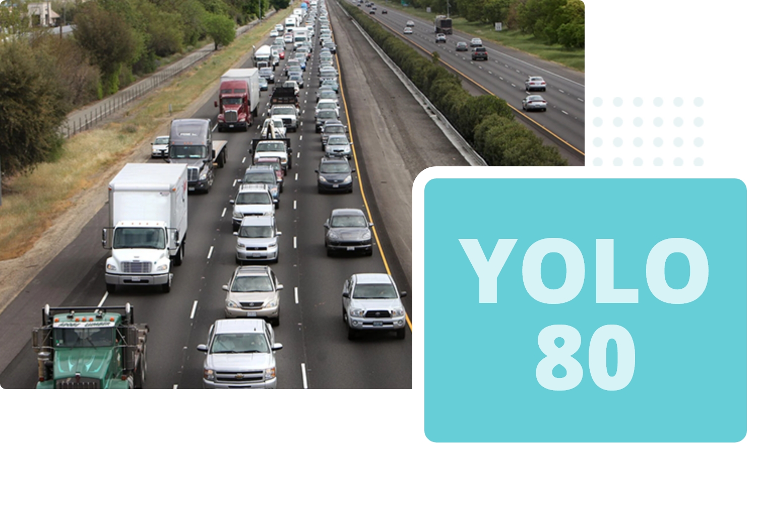
This project will address recurring congestion experienced during peak travel periods. The existing facility is currently operating above capacity and the proposed project aims to keep people and goods moving.
Project Status: Toll Planning & Policy in progress. Construction began Summer 2025.
What this Project Will Do
What this Project Will Do
- Reduce Congestion – Construct a new tolled managed lane along 17 miles of I-80, reducing bottlenecks without expanding the current footprint of the causeway.
- Prioritize Transit – Prioritize transit and carpools with adaptively managed lanes, minimizing climate emissions and using technology to detect and give priority to transit vehicles.
- Safe, Low-Stress Bicycle Facilities – Upgrade existing bike paths, ensuring safe and pleasant cycling on both the Davis and West Sacramento approaches.
- Support Local Communities – Reduce dangerous cut-through traffic and reinvest a portion of new toll revenue will be reinvested in local communities, with a focus on environmental justice communities.
Project Schedule
Fall
2019
Design and environmental review began
Spring
2021
$86 million INFRA grant awarded
Fall
2023
Draft Environmental Document (DED) released for public review
Spring
2024
Final environmental document and clearance completed
Spring
2024
$105 million TCEP grant awarded
Spring/Summer
2024
Design completed
Spring/Summer
2025
Construction starts
Spring - Spring
2025 - 2028
Toll Planning & Policy
Summer
2028
Construction complete and toll system launch
Project Goals
Project Goals
-
Support achievement of state and regional climate goals by limiting VMT increases and maximizing VMT reduction strategies.
-
Increase transit ridership and mode share.
-
Increase safety and ease of bicycle travel on the existing causeway bicycle path, including connecting routes in West Sacramento and Davis.
-
Advance transportation equity by minimizing project burdens and maximizing project benefits for low-income communities.
-
Improve peak hour travel time on I-80 while reducing the use of local streets and roads for regional trips.
-
Increased coordination with Solano County, Caltrans District 4, and MTC on interregional trips.
-
Improve traffic flow by using Intelligent Transportation Systems (ITS) technologies such as ramp metering.
-
Establish a highway management system that can be replicated and integrated regionwide.
Project Partners
Project Partners
![]()
Caltrans was the lead agency responsible for conducting environmental review to determine it the project would have significant environmental effects and clear the project for construction approval. Caltrans is also responsible for the implementation and oversight of the construction of the proposed changes to I-80.
Capital Area Regional Tolling Authority (CARTA) is a new Joint Powers Authority formed in January 2024 to develop and operate toll facilities in the Sacramento region. CARTA is currently comprised of elected representatives from YoloTD, SACOG, and Caltrans District 3. Voting representation in CARTA will grow as the region’s tolled managed lane network expands. CARTA is responsible for setting coordinated toll prices, rules, and discounts across the Sacramento region to reduce confusion for drivers; and for the distribution of surplus toll revenue.
SACOG is the Metropolitan Planning Organization of the Sacramento region and is responsible for regional and state level transportation planning. The SACOG Board of Directors approved the JPA agreement in January 20245, and currently manages CARTA staff.
Project Contacts
Autumn Bernstein, Executive Director
(530) 402-2812 | abernstein@yctd.org
Brian Abbanat, Director of Planning
(530) 402-2879 | babbanat@yctd.org
Project Updates
June 2021:YoloTD awarded $85.9 million INFRA grant
December 2021:YoloTD Board approves goals for Yolo 80 Managed Lanes project
Fall 2022:Caltrans begins Environmental Impact Report (EIR)
Fall 2022:YoloTD hires consulting firm WSP to assist with Tolling Advance Planning
Winter 2022:Caltrans submits $102 million construction funding grant application to the California Trade Corridors Enhancement Program (TCEP).
Winter-Spring 2023:YoloTD conducts outreach to key stakeholder groups
Spring 2023:TCEP funding awards announced, which excludes Caltrans’ $102 million construction funding request.
March 2023:Caltrans and YoloTD submit $3 million SACOG Transformative grant program application for non-construction activities
June 2023:YoloTD awarded $2 million from SACOG Transformative grant program for Tolling Advance Planning
November 2023:Caltrans released the Draft Environmental Impact Report (DEIR).
December 2023:YoloTD Board approves staff recommendation to submit a letter to Caltrans affirming DED Alternative #4 as Yolo Transportation District’s (YoloTD) preferred alternative for the Yolo 80 Managed Lanes project
January 2024:YoloTD Board appoints Chair Josh Chapman and Vice-Chair Dr. Dawnté Early to the CARTA Board.
January 2024:YoloTD Board approves staff recommendations approving: 1) The Joint Powers Authority (JPA) agreement with the Sacramento Area Council of Governments (SACOG) and the California Department of Transportation (Caltrans) establishing the Capitol Area Regional Tolling Authority (CARTA), and 2) Resolution consenting to CARTA’s submission of a Toll Facility Application to the California Transportation Commission (CTC) for Yolo 80 pursuant to Assembly Bill (AB) 194.
February 2024:FHWA Approves $85.9 million INFRA Term Sheet
March 2024:1) CARTA submits AB 194 Tolling Authority Application 2) altrans District 3 re-submits $105 million TCEP grant application
April 2024:1) Project Level Conformity Group makes Not A Project of Air Quality Concern determination 2) SACOG hosts Regional Planning Partnership Project Level Conformity Group Meeting for Yolo 80 Managed Lanes Project on 4/16/2024 at 2:00 p.m. 3) TC Hosts AB 194 Tolling Application Public Hearing on 4/9/2024 at 5:30 p.m. at Arthur F. Turner Community Library in West Sacramento
May 2024:Caltrans D3 files EIR Notice of Determination and publishes Final EIR (FEIR)
May 2024:CTC Approves: 1) $105 million TCEP grant application 2) CARTA tolling authority application
July 2024:YoloTD Board Accepts: 1) Yolo 80 Managed Lanes EIR and adopts Findings of Fact and Statement of Overriding Considerations 2)Approves Capital Project Transfer & Expenditure Agreement with Caltrans for $85.9 million INFRA funds 3) Approves RFQ for professional consulting services for Tolling Advanced Planning
October 2024:YoloTD Board approves professional consulting services agreement with Silicon Transportation Consultants for Tolling Advanced Planning
Additional Information
Below you can find more information and project documents.
The Project will construct approximately 17 center-line miles of Tolled Managed Lanes in both directions on Interstate 80 (I-80) and United States 50 (US-50) in Yolo County and portions of Sacramento County to alleviate bottlenecks and address an increasing capacity constraint.
Project components includes installation of Intelligent Transportation Systems (ITS) elements, such as fiber optics, detection, changeable message signs, to enhance mobility conditions and incident management strategies between jurisdictions; and improved bicycle and pedestrian access and safety to the eastern and western termini of the Yolo Causeway Class I facility that includes reduced curve radius, and analyze additional crosswalk, sidewalk, lighting, and safety elements.
The proposed improvements represent a scope guided by a variety of stakeholders from local and regional entities along the corridor. The Project begins at the Solano/Yolo County line on I-80 and ends at the I-80/West El Camino Avenue interchange, and on US-50 from the I-80/US-50 Interchange to the I-5/US-50 interchange, in Sacramento County. The project area includes the entire I-80 and US-50 corridors in Yolo County. This Project will result in direct and significant benefits to the economic vitality of the region by enhancing the operational performance and safety for regional and interregional travelers and national freight movement.
The I-80/US-50 corridors are subject to high travel demand, especially during peak commute periods and recreational weekend travel. The demand has created severe traffic congestion and impaired mobility along the route. At various locations, specifically I-80 through the city of Davis, and along the Yolo Bypass Causeway between the cities of Davis and West Sacramento, travel demand has exceeded highway design capacity, resulting in bottlenecks during the AM and PM peak periods. Multiple factors contribute to these bottlenecks, including high traffic volumes, short weaving and merging areas, lane drops, limited sight distances, lack of ITS elements, and incomplete bus/carpool, ramp metering, and auxiliary lane networks. Heavy congestion and stop-and-go traffic have contributed to increased vehicle emissions, increased travel costs, and reduced travel time reliability.
- September 8, 2025 (YoloTD Board): Update on Yolo 80 Managed Lanes VMT Mitigation Plan
- August 26, 2025 (YoloTD CAC): Update on Yolo 80 Managed Lanes Project
- July 14, 2025 (YoloTD Board): Update on Yolo 80 Managed Lanes Project
- March 10, 2025 (YoloTD Board): Update on Yolo 80 Managed Lanes Project
- October 15, 2024 (YoloTD Board): Professional Services Agreement with STC
- July 8, 2024 (YoloTD Board):
- May 13, 2024 (YoloTD Board): Update on Yolo 80 Managed Lanes Project
- May 7, 2024 (YoloTD CAC): Caltrans Cooperative Agreement
- April 8, 2024 (YoloTD Board): Update on Yolo 80 Managed Lanes Project
- March 11, 2024 (YoloTD Board): Update on Yolo 80 Managed Lanes Project
- February 12, 2024 (YoloTD Board)
- January 30, 2024 (YoloTD CAC): Update on Yolo 80 Managed Lanes Project
- January 22, 2024 (YoloTD Board)
- December 11, 2023 (YoloTD Board)
- November 13, 2023 (YoloTD Board):
- November 7, 2023 (YoloTD CAC): Update on Yolo 80 Managed Lanes Project
- October 9, 2023 (YoloTD Board): Update on Yolo 80 Managed Lanes Project
- September 11, 2023 (YoloTD Board): Update on Yolo 80 Managed Lanes Project
- July 17, 2023 (YoloTD Board): Update on Yolo 80 Managed Lanes Project
- June 12, 2023 (YoloTD Board): Update on Yolo 80 Managed Lanes Project
- May 8, 2023 (YoloTD Board): Update on Yolo 80 Managed Lanes Project
- April 10, 2023 (YoloTD Board): Update on Yolo 80 Managed Lanes Project
- March 13, 2023 (YoloTD Board): Update on Yolo 80 Managed Lanes Project
- February 13, 2023 (YoloTD Board): Update on Yolo 80 Managed Lanes Project
- January 31, 2023 (YoloTD CAC): Update on Yolo 80 Managed Lanes Project
- January 9, 2023 (Yolo TD Board):
- October 10, 2022 (YoloTD Board): Resolutions on Memorandum of Understanding (MOU) and Funding Application
- July 11, 2022 (YoloTD Board): Project Update & Authorization to Publish RFP
- January 10, 2022 (YoloTD Board): Informational Workshop on Yolo 80 Managed Lanes Project
- December 13, 2021 (YoloTD Board): Goals for 80 Managed Lanes
- November 8, 2021 (YoloTD Board): Establish an I-80 Managed Lanes Ad Hoc Committee
- October 11, 2021 (YoloTD Board): Presentation by Caltrans on the I-80 Improvements Project